


Bridging the Gap Between Land Surveying and Tree Preservation
Bridging the Gap Between Land Surveying and Tree Preservation
Land development begins with a foundation of accurate measurements—and that foundation is the land survey. But too often, tree preservation is treated as a secondary concern, added after the fact to appease permitting bodies or neighborhood concerns. This disjointed approach can lead to costly redesigns, ordinance violations, and missed opportunities for sustainability.
By integrating arborist insights into the land surveying process, developers and civil engineers can plan smarter, avoid pitfalls, and preserve valuable canopy. At Tree Mann Solutions, we work closely with surveyors to ensure tree data informs and enhances the entire development lifecycle.
The Disconnect Between Surveying and Arboriculture
In many projects, land surveys are completed early to determine things like property lines, topography, and elevation. However, various aspects of trees (condition, species location, etc.) are often excluded or added later as a separate effort.
Some of the consequences of this disconnect are inaccurate site plans that conflict with tree ordinances, redesigns to avoid protected trees after initial approval, overlooked root zones during grading and trenching, delays in permitting and inspections, and more.
Arborists and surveyors possess different expertise, but their work is complementary. Accurately combining insights early in the development process leads to more accurate development, right off the bat.
So how is tree data involved?
Some things a tree informed survey can include are:
– Tree species identification
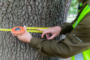
– Trunk diameter (DBH) measurements
– GPS coordinates of trunk locations
– Canopy spread and root zone estimates
– Health and condition ratings
– Notes on ordinance status or heritage designation
This data helps determine which trees are subject to local protection laws, and how development and design plans should adapt to comply with them.
Working with Municipal Ordinances
Most Texas cities regulate tree removal based on DBH, species, and location. Some municipalities require tree surveys to be certified by a Registered Professional Land Surveyor (RPLS), while others do not.
Even when an RPLS is not explicitly required, collaboration between arborists and surveyors is important for rigorous quality control, and for survey-grade locations on larger trees that are integral to design and will be saved close to designed improvements.
Including protected trees in the initial survey avoids surprises and strengthens your permit package. Being thorough in tree data collection can save valuable time and money in the development process.
How Surveyors and Arborists Collaborate
– Integrated Data Delivery
We provide GIS or CAD-compatible files so tree data can be imported into survey plats and site plans. This makes the process of data transfer and collaboration much smoother.
– Tagging and Mapping
Each tree is tagged with an ID, and its location is plotted using the same geodetic framework as the survey. This ensures proper placement of the trees and their canopies, making design around protected trees accurate and efficient.
– Coordinated Reports
Tree preservation plans reference the same coordinates and tree IDs as the survey documents, simplifying communication with planners and engineers.
Case Study: Residential Development in Buda
A surveyor working on a 15-acre residential development in Buda brought in Tree Mann Solutions to document trees before platting. We identified 22 protected trees near lot lines and drainage easements. By collaborating before finalizing grading plans, the team preserved 80% of those trees without sacrificing buildable area.
Benefits of Early Arborist Involvement
– Reduces permitting delays
– Eliminates improper identification and classification
– Prevents conflicts with root zones during trenching
– Supports variance requests with professional data
– Improves community reception of development projects
– Strengthens the reputation of survey and development teams
Tools and Technology
Tree Mann Solutions uses:
– GPS tools for accurate plotting
– GIS platforms for overlaying trees with data
– CAD-ready tree lists and attribute tables
Recommendations for Surveying Teams
– Include “tree condition and protection” in your initial scope of work
– Partner with Certified Arborists that are local and familiar with local ordinances
– Deliver survey files with layers for topography, trees, and utilities
– Encourage clients to assess trees before staking or grading
Surveyors and arborists aren’t working against each other; they’re working toward the same goal from different angles. By integrating detailed tree data into land surveys, projects stay on track, meet environmental regulations, and preserve the natural features that give spaces their lasting value!
Tree Mann Solutions partners with surveyors to deliver precise tree mapping and practical protection strategies to map trees with precision and purpose!
Share this Post

